Extreme Weather: What Farmers Need to Know
Explore these resources on dust storms, heavy rainfall events, and high winds and derechos, as well as a glossary of weather-related agricultural terms and conservation practices.
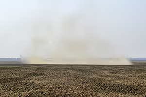
Dust Storms
A dust storm occurs when strong winds lift large amounts of loose sand, silt, and other soil components from dry surfaces into the air, creating a dense cloud that can travel long distances. Get the guide to learn more about the impact, the areas of greatest risk, farm management recommendations, and how to be part of the solution.
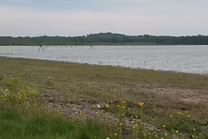
Heavy Rainfall Events
A heavy rainfall event occurs when intense amounts of rain falls in a short amount of time (at more than 0.3 inches per hour), and substantially exceeds what is normal for that location or season. These events can cause significant economic, agronomic, or infrastructure damage from runoff, erosion, inundation, and flooding. Get the guide to learn more about the impact, the areas of greatest risk, farm management recommendations, and how to be part of the solution.
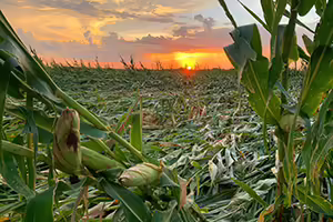
High Winds and Derechos
The National Weather Service characterizes a high wind event as sustained winds of approximately 40 mph (64 km/h) or greater for one hour or longer. It also includes events with gusts of 58 mph (93 km/h) or greater for any duration, which are strong enough to cause infrastructure and crop damage. A derecho is a particular kind of severe convective windstorm that is a long-lived, fast-moving band of thunderstorms that produces widespread, straight-line wind damage. Get the guide to learn more about the impact, the areas of greatest risk, farm management recommendations, and how to be part of the solution.
Glossary
This glossary of weather-related agricultural terms and conservation practices is available to help the Illinois agricultural community navigate extreme weather events and build farm resilience.
Agroforestry
A land-management approach that intentionally integrates trees and shrubs with crops and/or livestock, enhancing productivity, carbon sequestration, soil health, water quality, and climate resilience. Source: USDA National Agroforestry Center.
Contour buffer strips
These are narrow, permanent bands of perennial vegetation laid out around a hill or slope, and altered down the slope with wider cropping strips, designed to slow runoff, reduce soil erosion, and improve water infiltration. Source: USDA NRCS Conservation Practice Standard Code 332.
Conservation buffers
A general term referring to any strategically placed area of permanent vegetation — including riparian buffers, filter strips, windbreaks, and grassed waterways — used to protect soil, water, air, and biodiversity while increasing farm and watershed resilience.
Conservation tillage, reduced tillage, or no till
Tillage practices that reduce or limit soil disturbance to manage the amount, orientation and distribution of crop and plant residue on the soil surface year round; this can include “strip tillage” where only in-row soil disturbance occurs; “reduced or conservation tillages” which reduces the extent of land that is tilled or the number of passes with a tiller; and “no till” which mean no tillage is done between crop seasons and plant residues are allowed to stay undisturbed on the soil surface. Source: USDA NRCS Conservation Practice Standard Code 329.
Cover crops
Cover crops are non-cash crops planted between or alongside main crops to protect soil from erosion, improve soil health, suppress weeds, enhance nutrient cycling, and increase resilience to extreme precipitation and drought. Source: USDA NRCS Conservation Practice Standard Code 340.
Field-edge buffers
Field-edge buffers are permanent vegetated areas established at the margins of fields to trap sediment and nutrients, reduce pesticide drift, improve water quality, and provide wildlife habitat. Source: USDA NRCS Conservation Practice Standard Code 386.
Hedgerow
A hedgerow is a linear planting of shrubs and small trees—often native species—installed along field edges or boundaries to reduce wind erosion, support pollinators and beneficial insects, improve wildlife habitat, and intercept surface runoff. Source: USDA NRCS Conservation Practice Standard Code 422.
Wind break
A wind break is a single or multiple rows of trees and/or shrubs planted to reduce wind speed, thereby protecting crops, livestock, soil, buildings, and farmsteads while also conserving soil moisture and improving microclimates. Source: USDA NRCS Conservation Practice Standard Code 380.
Soil properties
Soil organic matter
Soil organic matter is the fraction of soil made up of plant and animal residues at various stages of decomposition, cells and tissues of soil organisms, and substances synthesized by soil organisms. SOM is critical for nutrient cycling, soil structure, water holding capacity, and carbon storage. Source: USDA NRCS.
Infiltration
Infiltration is the process by which water on the soil surface enters the soil. Infiltration rate affects runoff, erosion, groundwater recharge, and plant water availability and is strongly influenced by soil structure, organic matter, and management practices. Source: USDA NRCS.
Soil bulk density
Soil bulk density is the mass of dry soil per unit volume, including the air space. It is an indicator of soil compaction, root penetration potential, water movement, and overall soil physical condition. Source: USDA NRCS.
Other
Highly Erodible Lands
Highly erodible lands are any land that can erode at excessive rates because of its soil properties and is designated as such by the USDA by field and based on the proportion of the total field acreage that contains highly erodible soils. Highly Erodible Land Conservation (HELC) provisions aim to reduce soil loss on erosion-prone lands. These provisions apply to all land considered highly erodible and is owned or farmed by persons voluntarily participating in USDA programs, unless USDA determines an exemption applies; non-compliance with HELC can affect ability to access other USDA beneficial programs such as farm insurance, disaster assistance, and farm loan programs. Source: USDA NRCS.
The Illinois Nutrient Loss Reduction Strategy
The Illinois Nutrient Loss Reduction Strategy is an Illinois statewide collaborative effort and science-based strategy working to reduce the amount of nutrients, particularly nitrogen and phosphorus, entering Illinois waterways. The strategy promotes the reduction of nutrients in a coordinated manner by recommending cost-effective, practical actions and best management practices.