Drone technology is increasing in its applicability in improving farm operations. University of Illinois Extension Fulton-Mason-Peoria-Tazewell Unit Farm Management Educator Kevin Brooks uses drones to assist local farmers with issues and provides practical advice on how to efficiently and effectively use a drone on the farm.
Crop plant health varies throughout the growing season depending on conditions in the field. Driving or walking along a field edge shows what is going on where one can see, but it is not as helpful in monitoring what is happening further in a field. Drones, on the other hand, can help farm producers monitor an entire field.
In a particular field, there are many different soil types that can cause a crop variety to act differently in one area than another. Weed, pest, and disease pressures also vary across a field.
“The key to efficiently using a drone in the farm operation is to quickly identify problem areas in the field and then do a more in depth look at the situation,” Brooks explained. “In a 160 acre field area, doing a quick look from 200 feet in the air shows a lot about conditions. The pilot can then fly the drone lower and examine the crop more closely.”
In many instances, the closer look provides a good view of conditions. For example, if a small area of an invasive weed species or disease is noted, the pilot can mark the location using Real Time Kinematic (RTK) position technology and go to the exact spot in the field. If using position technology, which is less precise than RTK, a general area of the field may be noted for spraying instead.
Brooks further explained, “There are a lot of potential uses on the farm. Wet spots needing drainage or nitrogen deficiencies are just a few examples of what can be seen from the air. The drones can be simple machines for quick looks or more sophisticated for highly detailed maps.”
Brooks also uses Extension farm drones to monitor overall field health. “Using platforms such as Drone Deploy or Agremo can give the farmer an overall view of the field for problems and will do valuable crop plant population stand counts. “Taking a stand count doesn’t take a lot of time. An in depth look at an entire field, however, can take considerable time to map for overall conditions. On a 160 acre field, a farmer might only want to detail known problem areas noted in a basic overview flight.
“Mapping an entire field with high detail can result in an autonomously flying drone taking thousands of photos. These photos are stitched together into one map. This mapping step for an 80 acre field can take nearly an hour. Additionally, the after flight work of uploading photos can take as long as it does to fly the map route.”
PHOTO CAPTION
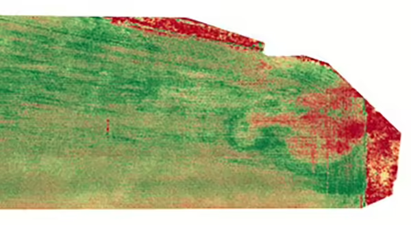
Illinois Extension Educator Kevin Brooks used a MAVIC 3M drone using near infrared imaging to map this local field which indicates herbicide damage on the right side of the image. Drones can be used to assist farmers with crop conditions throughout the growing season.
MEET THE AUTHOR
Kevin Brooks became the farm business management and marketing educator serving Fulton, Mason, Peoria, and Tazewell counties in 2022. He previously served in this role from 2000 to 2011 in Effingham and Champaign counties.
Kevin grew up on a corn and hog farm in Iowa. He received his bachelor of science degree in agriculture business from Truman State University and his master of science degree from University of Missouri in agriculture education.
Kevin is a fully licensed managing real estate broker in Mahomet, Illinois.He holds agriculture teaching certifications in Illinois and Missouri. He is also a commercially licensed UAS (drone) pilot holding an FAA Part 107 license.
ABOUT EXTENSION SNAPSHOTS
Extension Snapshots are monthly impact reports that share the stories of our programs in Fulton, Mason, Peoria, and Tazewell counties. To have them delivered to you directly sign up using our E-blast registration.