Today, NOAA-supported scientists announced that this year’s Gulf of Mexico “dead zone”— an area of low to no oxygen that can kill fish and marine life — is approximately 3,058 square miles. That’s almost two million acres of habitat potentially unavailable to fish and bottom species — nearly as large as the land area of Yellowstone National Park.
The five-year average size of the dead zone (also known as the hypoxic zone) is now 4,347 square miles, which is over two times larger than management targets. Since records began in 1985, the largest hypoxic zone measured was 8,776 square miles in 2017. This is the seventh smallest zone on record in the 37 year measurement history.
The measurement was made during an annual survey cruise, led by a team of scientists from Louisiana State University and the Louisiana Universities Marine Consortium (LUMCON) aboard the R/V Pelicanoffsite link during the last week of July. The information gathered is a key metric used by the Mississippi River/Gulf of Mexico Hypoxia Task Force to measure progress toward achieving their five-year average target of getting the dead zone to 1,900 square miles or smaller by 2035. The cruise provides a one-time snapshot of the dead zone; the five-year average captures the dynamic and changing nature of the zone over time.
“With more frequent and intense weather events in the Gulf of Mexico and elsewhere, it is imperative that we continue to measure hypoxia in this region as an indicator of ocean health and progress toward management targets,” said Nicole LeBoeuf, director of NOAA’s National Ocean Service. “The data collected from this annual, long-term research program helps decision-makers fine tune strategies to reduce the size of the hypoxic zone and mitigate harmful impacts to our coastal resources, communities and economy.”
University of Illinois Extension partners with the Illinois Environmental Protection Agency and Illinois Department of Agriculture to implement the Illinois Nutrient Loss Reduction Strategy. Illinois is one of 12 states that have developed nutrient strategies to meet the goals of the U.S. EPA Gulf Hypoxia Action Plan. The Illinois NLRS goals are to reduce the nutrient pollution that leaves Illinois via the Mississippi River; and to improve the local water quality of streams, rivers, and lakes for Illinois residents.
Read the full release from the National Oceanic and Atmospheric Administration.
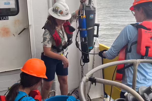
Photo: Scientists MacKenzie Smith from LUMCON (back center), Abby Roche from LSU (front center) and Emily Savoie from LSU (right) collect near-bottom water aboard the R/V Pelican to obtain oxygen measurements used to determine the size of the Gulf of Mexico hypoxic zone. (Image credit: LUMCON/LSU)
Illinois Extension leads public outreach for University of Illinois by translating research into action plans that allow Illinois families, businesses, and community leaders to solve problems, make informed decisions, and adapt to changes and opportunities. Illinois Extension is part of the University of Illinois Urbana-Champaign College of Agricultural, Consumer and Environmental Sciences.