When thunderstorms are predicted for your area, weathercasters will often include information on the severity of projected storms. What does this information mean?
What makes a thunderstorm severe?
The National Weather Service defines a severe thunderstorm as any storm that produces one or more of the following elements:
- A tornado.
- Damaging winds or speeds of 58 mph (50 knots) or greater.
- Hail 1 inch in diameter or larger.
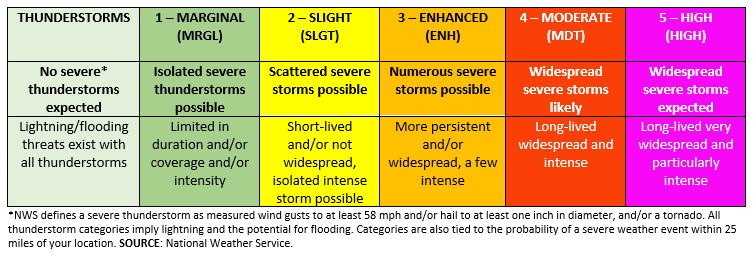
The Storm Prediction Center (SPC), part of the National Weather Service, uses a risk category scale of 1-5, with a 1 representing a few isolated severe storms and 5 for widespread severe storms that will be very intense and long lived.
The SPC issues Day 1, Day 2, and Day 3 outlooks that show non-severe thunderstorm areas and severe thunderstorm threats across the contiguous United States, along with a text narrative. This forecast expresses the best estimate of a severe weather event occurring within 25 miles of a point. Day 1 and 2 forecasts are made with separate probabilities of tornadoes, wind, and hail, while a Day 3 forecast combines all three.
What are the details for each category?
- For non-severe thunderstorms there will be a light green color with no number. This shows where a 10% or greater probability of thunderstorms is forecast during the designated period. This can happen on a lot of warm summer days, especially in the afternoon.
- Category 1 is shown as dark green and represents a marginal risk of severe storms. This can be for an area of severe storms that may be limited in how long they last or very low coverage and on the low end of severe intensity.
- Category 2 is shown in yellow and represents a slight risk for severe storms. An area of severe storms that may include multiple hazards but is not widespread in coverage with varying levels of intensity.
- Category 3 is orange and signifies an enhanced risk for severe storms. This is for an area of greater (relative to slight risk) severe storm coverage with varying levels of intensity.
- Category 4 is red and indicates a moderate risk of severe storms. Widespread severe weather with several tornadoes and/or numerous severe thunderstorms is likely, some of which should be intense. This risk is usually reserved for days with several supercells producing intense tornadoes and/or very large hail, or an intense squall line with widespread damaging winds.
- The number 5 category is magenta and represents a HIGH risk. In this area, a severe weather outbreak is expected from either numerous intense and long-tracked tornadoes or a long-lived derecho-producing thunderstorm complex that produces hurricane-force wind gusts and widespread damage. This risk is reserved for when high confidence exists in widespread coverage of severe weather with embedded instances of extreme severe such as violent tornadoes.
How do we know when to be really concerned?
Are the names confusing? Studies show they can be, so I encourage you to just look at the colors. Orange, red, or magenta should convey that you need to be wary of the weather and be prepared to move to safety if needed. Red and magenta are not used very often, so if you see they are shown for your location, have a way to monitor the weather closely.
ABOUT THE BLOG: All About Weather is a blog by Duane Friend that explores the environment, climate, and weather topics for Illinois. Get in-depth information about things your weather app doesn't cover from summer droughts to shifting weather patterns. Never miss a new post! Sign up for our email list.
MEET THE AUTHOR: Duane Friend is the Illinois Master Naturalist Coordinator and Climate Specialist with University of Illinois Extension, serving the organization in many roles since 1993. Duane provides information and educational programs to adult and youth audiences in the areas of soil quality, weather and climate, energy conservation, and disaster preparedness. These programs provide practical solutions for families, farms, and communities. He assists families in creating a household emergency plan, farmers with the implementation of soil management and conservation practices, and local government officials and business owners with energy conservation techniques.
RESOURCES
- Storm Prediction Center Frequently Asked Questions
- Storm Prediction Center Products
- Storm Prediction Center Convective Outlooks
- Washington Post. The National Weather Service issues highly accurate thunderstorm forecasts. Matthew Cappucci. April 2020