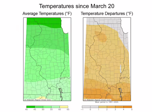
From Trent Ford, Illinois State Climatologist. Spring temperatures have been very typically variable so far across the Midwest. Average temperatures since mid-March have been 1 to 3 degrees above normal statewide (Figure 1). Despite the warmer conditions, we had a few frost and freeze events in the first two weeks of April, including widespread temperatures below 32 degrees on the morning of April 8th.
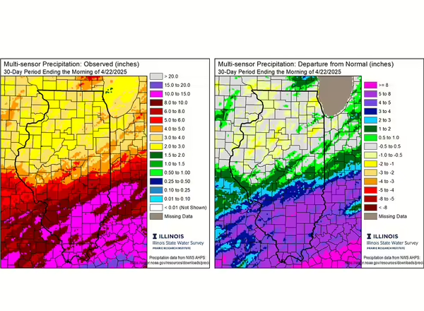
Spring has also brought very active weather including several rounds of storms that produced very heavy rain and some severe weather. Most noteworthy was a stalled out frontal boundary that produced exceptionally heavy rain across southern Illinois and the broader mid-south between April 9th and 13th. Much of southern Illinois picked up between 6 and 12 inches of rain in just four days, causing widespread river flooding and standing water in many places. The eye-popping precipitation totals added to a relatively wet March. Precipitation totals over the past 30 days range from around 2.5 inches in northwest Illinois to over 15 inches in far southern Illinois. Most of central and northern Illinois have been within 1 inch of normal since mid-March, while southern Illinois has been 5 to 10 inches wetter than normal over that time (Figure 2).
We are already two-thirds of the way through climatological spring. Outlooks for the rest of the season, though the end of May, show best chances of a continued wetter pattern statewide. This likely means continued active stormtrack, which will keep soils very wet across southern Illinois. The outlooks for the next 3-4 weeks and the month of May both show equal chances of below and above normal temperatures. This likely means low risk of hard freeze south of Interstate 80 moving forward.