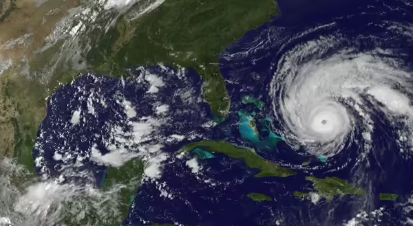
At the writing of this post on September 2, we are in the average peak week of hurricane activity for the Gulf of Mexico. Remnants of hurricane Ida are drenching the East Coast, and a new hurricane is currently out in the Atlantic.
The Earth’s weather is a complex system of winds, moisture, and heat. Hurricanes are a good example of all of these. They move huge amounts of heat from the hot tropics to the milder middle latitudes.
What makes them form, and how do they move heat? I’m so glad you asked!
How hurricanes form
Hurricanes start as thunderstorms
Hurricanes that hit the United States either form in the Gulf of Mexico or start just off the coast of Africa. Especially for those in the Atlantic, they first are just a weak area of thunderstorms called an Easterly Wave. The Easterly part is because they form in the area where winds move from east to west, which occurs from about 30 degrees north and south latitude to near the Equator.
As the thunderstorms build up, they release heat into the atmosphere as water vapor, the gas form of water, condenses into liquid water. This added heat allows the thunderstorms to build up even more. The rising air in thunderstorms causes air at the surface to move in to replace it. This moist ocean air also starts to rise, allowing the thunderstorms to continue to grow.
Because of Earth’s rotation, the incoming surface air takes on a spiraling inward motion. North of the Equator, the inward spiraling is counterclockwise. The spiraling motion doesn’t occur right on the Equator. Yes, the earth is still rotating there, but the laws of nature don’t make air spiral there. You will never see a hurricane right on the Equator. I will write a separate blog post to explain all of that.
Ingredients for a hurricane
For those storms to grow into a hurricane, several things need to be in place.
- It needs to be fed by warm moist air. Ocean temperatures need to be at least 80°, and that warm water needs to be a least 150 feet deep. Gulf of Mexico temperatures are very warm and may exceed 85°.
- Upper-level winds need to be weak. If upper-level winds are strong, thunderstorms can’t grow and get stronger. That helps explain why not every year produces a lot of strong hurricanes, as strong upper-level winds may hinder hurricane development.
Why is the first week of September the peak for hurricane development in the Gulf? Because that is when water temperatures there are the warmest. Large bodies of water typically lag behind the high and low sun by about two months in their high and low temperatures. The high sun for the Gulf would have occurred around June 21.
How hurricanes move heat
Remember I said that as water vapor condenses it releases heat into the atmosphere? Think about the movement of hurricanes. Over time they move away from tropical areas into the middle latitudes.
All that condensation in the hurricane takes that heat from warm tropical air and releases it many hundred or a thousand miles away from where it was picked up. This helps even out the temperature difference between the Equator and the poles.
Hurricanes and climate change
As we look down the road, it’s not completely clear what the trend will be. As ocean temperatures warm, it will probably mean the potential for a greater number of strong hurricanes, but the overall numbers of hurricanes may not increase. Not a great scenario, so preparation will be important.
MEET THE AUTHOR
Duane Friend is an energy and environmental stewardship educator with University of Illinois Extension, serving the organization in many roles since 1993. Duane provides information and educational programs to adult and youth audiences in the areas of soil quality, weather and climate, energy conservation, and disaster preparedness. These programs provide practical solutions for families, farms, and communities. He assists families in creating a household emergency plan, farmers with the implementation of soil management and conservation practices, and local government officials and business owners with energy conservation techniques.
ABOUT THE BLOG
All About Weather is a blog that explores the environment, climate, and weather topics for Illinois. Get in-depth information about things your weather app doesn't cover from summer droughts to shifting weather patterns.