As I write this, folks just a few miles away are sawing up downed trees and clearing debris from severe wind damage that occurred during a round of thunderstorms passing through the area the night before.
No tornado was observed either by eye or on radar, so it appears to have been caused by straight-line winds. However, the worst of the damage was confined to a narrow area and is over a mile long. The relatively small area of damage may have been due to a microburst, a localized area of strong downward air that hits the ground and spreads out.
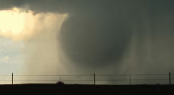
What causes a microburst?
Thunderstorms develop as air rises in an updraft. More air is brought in to replace the air that is rising. Many times the air is moist, making the updraft more buoyant. However, on some occasions, the air brought in is dry, which causes water droplets in the updraft to evaporate and cool. The cooling may cause the updraft to weaken or stop. Since both cool and dry air is heavy, the air sinks rapidly. Sometimes suspended hail and rain come down too, adding to the wind velocity as these particles drag air down.
Once the air hits the ground, it quickly spreads out. The front edge of the air wraps around itself, adding to the wind speed. A 50 mph wind can become a 100 mph wind in the area where the air develops this rolling. Microbursts may or may not contain precipitation.

Downburst Discovery
This phenomenon was first described by meteorologist Tetsuya “Ted” Fujita, better known for the Fujita scale of tornadic wind damage. After a commercial jet crashed in the mid-1970s while attempting to land during a thunderstorm, Dr. Fujita suspected a strong downdraft caused the crash. His theory was based on previous aerial observations showing a starburst pattern of damage from a central point after thunderstorms had passed through an area. It took some time before his theory was shown to be correct, but now airports are very vigilant for microbursts when thunderstorms are close by.
Predicting a microburst is not easy
Since this phenomenon is small in scale and happens rapidly. It is not currently possible to provide advance warning on where exactly microbursts will occur. Weather radar can detect these as they occur, if the radar is not too far away. Certain weather conditions may provide a general likelihood of microburst development which are in many cases the same conditions for severe thunderstorm development.
Resources
- National Weather Service: www.weather.gov/bmx/outreach_microbursts
- National Science Foundation: www.nsf.gov/discoveries/ disc_summ.jsp?cntn_id=100485&org=NSF
Photos: NOAA
MEET THE AUTHOR
Duane Friend is an energy and environmental stewardship educator with University of Illinois Extension, serving the organization in many roles since 1993. Duane provides information and educational programs to adult and youth audiences in the areas of soil quality, weather and climate, energy conservation, and disaster preparedness. These programs provide practical solutions for families, farms, and communities. He assists families in creating a household emergency plan, farmers with the implementation of soil management and conservation practices, and local government officials and business owners with energy conservation techniques.
ABOUT THE BLOG
All About Weather is a blog that explores the environment, climate, and weather topics for Illinois. Get in-depth information about things your weather app doesn't cover from summer droughts to shifting weather patterns.