You’ve probably heard these weather terms many times - El Nino and La Nina. They seem to affect our weather and they come and go. Are they normal to occur? Where do they occur? Why does it affect our weather?
What is La Nina?
In this post, I’ll focus on La Nina since that is what will likely affect our 2021-22 winter weather.
First of all, both La Nina and El Nino are not new. They have been known for decades, if not hundreds of years particularly along the western coast of South America, where these events can cause major changes in weather. Meteorologists, however, have gotten better at predicting when they’re going to occur, and how it affects weather in areas like the Midwest.
The factors that make La Nina occur are in the Pacific Ocean between South America and Australia near the Equator. Winds on average blow toward Australia and surface ocean currents go in the same direction. This makes for a blob of warm water near Northern Australia. Along the western coast of South America, there is a bunch of cold water that has come up from the depths to replace the water that’s heading toward Australia. During a La Nina event, winds and currents toward Australia are much stronger, making for more warm water near Australia and cold water along western South America.
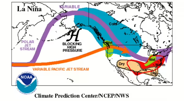
These stronger conditions, including air pressure differences, change the average position of jet streams in the atmosphere, including the Polar Jet that affects us, especially during the winter. The Polar jet acts as a boundary between the very cold air in the higher latitudes and the more mild air farther south. Over the Pacific, it may split into two jets, then come back together over the western United States. For Illinois, the average La Nina winter position of the polar jet is right over Illinois, as the above NOAA diagram shows.
What does that mean for our winter?
For our winter, it really depends on whether the jet stream actually ends up. If it starts hooking back to the north say over Iowa, we could end up with a warmer and wetter winter. If it hooks to the north, more in Indiana or Ohio, we may end up with colder and drier conditions. If it stays over Illinois, we could get several intervals of warm and wet and cold and dry periods.
The one thing that may bode well for the western U.S is the splitting of the jet stream, which may allow for several atmospheric rivers to bring lots of rain and snow to the Northwest to bring some much-needed snowpack to that region.
What’s an atmospheric river? So glad you asked! Find out in a future post!
Photo credit: NOAA Climate Prediction Center
MEET THE AUTHOR
Duane Friend is an energy and environmental stewardship educator with University of Illinois Extension, serving the organization in many roles since 1993. Duane provides information and educational programs to adult and youth audiences in the areas of soil quality, weather and climate, energy conservation, and disaster preparedness. These programs provide practical solutions for families, farms, and communities. He assists families in creating a household emergency plan, farmers with the implementation of soil management and conservation practices, and local government officials and business owners with energy conservation techniques.
ABOUT THE BLOG
All About Weather is a blog that explores the environment, climate, and weather topics for Illinois. Get in-depth information about things your weather app doesn't cover from summer droughts to shifting weather patterns.