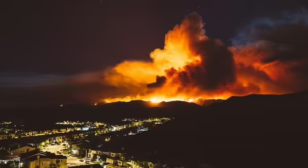
At the time I’m writing this, a tragedy is occurring in the Los Angeles area. Thousands of acres have burned, and countless homes, businesses, and vehicles have been lost to wildfires spurred on by intense winds.
The mechanism that led to this epic event is not new, but it is rare that it occurs with such strength and could not have come at a worse time. Near Los Angeles is a community named Santa Ana. Strong downhill winds here are named Santa Ana winds because these winds occur near this community and this is where these winds can slip through the mountains.
What are Santa Ana Winds?
Santa Ana winds are a type of wind known as a Foehn or Chinook wind. When air flows down the slope of a mountain range, it gets compressed, because it is moving deeper in the atmosphere, where the air pressure is greater. As the air compresses, it also warms. For every 1,000 feet that air moves down in elevation, the temperature will increase by 5.5 degrees Fahrenheit. For example, air that is 50 degrees near the top of a 5,000-foot mountain will have warmed to nearly 78 degrees when it has moved to the base of the mountain.
Another aspect of this wind is, that even though it may start with a low relative humidity, the humidity gets even lower as the air warms. Foehn or Chinook winds are common around the globe, and while they may bring warmer temperatures to a location, they generally do little damage.
In fall and winter, sometimes there is a large area of high pressure over the desert areas of Nevada and Utah. The clockwise outward flow of air around the high pressure causes air to move down the southern coastal California mountain slopes and towards the coast. When the wind is squeezed through canyons, the wind speed increases; 30-50 mph is common.
Two things increased wind speed in mid-January 2025: A strong high pressure over Utah, and an area of low pressure near Baja California. This counterclockwise air flow from the low pressure aided in increasing Santa Ana winds, as can be seen in the graphics below from the Null Earth website. Extreme fast-moving winds, especially those pushing through valleys just to the east of L.A., exceeded 70-80 mph.
But why are there so many fires?
Southern California’s wet season occurs from December to March, although the rain may be little. As Albert Hammond’s hit 1970s song notes, “It Never Rains in Southern California.” When it does rain, vegetation greens up and grows for a few months, but then dies out in late summer and fall. If the rain does not come early in winter, the dead vegetation is a powder keg waiting for a spark. When fires start, California fire crews can usually contain the fire zone quickly. But, when Santa Winds are blowing, the embers from the fire can be blown long distances, and it becomes impossible to contain. In this situation, it becomes a matter of defense and evacuation.
Personal, social, and economic costs
We may think of this event as just affecting those directly involved in the fires. But California is an economic powerhouse, and these fires will have a ripple through the rest of the U.S. economy, not to mention the health and mental trauma inflicted on thousands of people. University of Illinois researcher David Molitor, associate professor of finance Gies College of Business, recently reported that acute air pollution from wildfire smoke has a widespread impact on human health well beyond where the fires occur.
No rain in Southern California is not always a good thing.
About the Blog
The All About Weather blog by Duane Friend explores the environment, climate, and weather topics for Illinois. Get in-depth information about things your weather app doesn't cover, from summer droughts to shifting weather patterns. Never miss a new post!
January 8, 2025, Weather Maps
1. Surface High and Low Air Pressures Jan. 8, 2025, from Weather.com.
2. Surface winds on Jan. 8, from Null Earth.
3. The winds at about 18,000 feet up. Los Angeles, in the red/purple section, has the highest wind speeds. From Null Earth.
")
")
