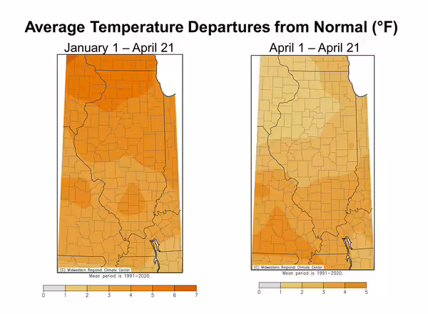
Illinois experienced its 2nd warmest winter on record, cooler only than 1932. The mild winter caused perennials to break dormancy and advance phenology weeks ahead of average. While March and April have had their characteristic temperature swings, milder weather has persisted into the spring so far. Year to date air temperatures through April 21st have run 2 to 7 degrees warmer than normal, and the first two thirds of April has been 1 to 5 degrees warmer than normal (Figure 1).
The overall average seasonal temperature in winter and spring does not have a strong association with the timing of spring frost and freeze. So, despite the overall warmer weather since the start of the year, much of the state north of Interstate 70 experienced widespread frost or freeze last week. In fact, many places – including as far south as Vandalia saw temperatures dip below freezing on April 21st, which is 1 to 2 weeks after the climatological average last spring freeze in south-central Illinois.
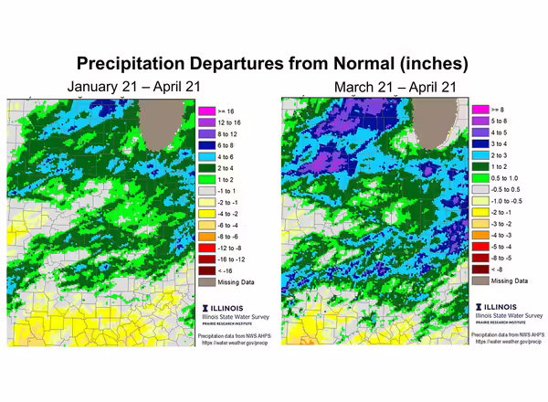
Following the second driest February on record statewide, March and April have brought a more active stormtrack and precipitation to the state. Parts of northern Illinois have had well over 12 inches of rain since mid-March, 5 to 8 inches above normal (Figure 2). Meanwhile, much of central Illinois has been 1 to 3 inches wetter than normal since mid-March, and close to normal since January. Far southern Illinois started 2024 very dry, following an extremely dry fall, which increased concerns of drought in that part of the state. Recent April rains have eaten away at some of those deficits and helped boost deeper layer soil moisture in southern Illinois.
Unfortunately, not all March and April precipitation has been rain. The last 6 weeks have been very hail-active across Illinois. In fact, the Storm Prediction Center’s preliminary count had 68 severe hail reports across Illinois in March, and already more than two dozen in April.
Looking ahead, models are showing milder temperatures persisting through the end of April, and higher chances of above normal temperatures in May as well. These outlooks don’t consider the risk of frost or freeze, but our freeze risk greatly decreases after the first week of May for all but far northern Illinois. Meanwhile, the next 6 to 10 days are expected to be very wet in Illinois, with forecasts of 1 to 4 inches by the end of the month. However, May outlooks show best chances of near normal precipitation, so fieldwork opportunities should open in earnest in the first half of May.
This article was submitted by Trent Ford, Illinois State Climatologist 217-244-1330 twford@illinois.edu