Monthly report by Trent Ford, Illinois State Climatologist
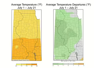
Illinois experienced a top 20 warmest June on record statewide, but much of that heat came in the first two-thirds of the month. However, temperatures have been much milder since the summer solstice, thanks to a large atmospheric ridge that has parked itself over the western U.S., keeping somewhat consistent northwest flow into the Midwest.
Average temperatures in the first two-thirds of July were between 1 and 3 degrees below average across the state. Many places saw nighttime low temperatures dip into the low 50s and high 40s in the second week of the month, including 47 in Dwight and 48 in Decatur.
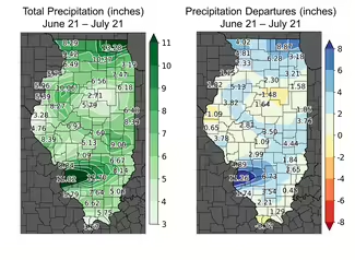
Some areas in western, central, and south-central Illinois were beginning to dry out in late June following a stretch of dry and hot weather. However, drought was largely avoided in these areas thanks to the one-two punch from the remnants of Hurricane Beryl and a series of strong storms – including a derecho – the following week. The more active weather in July has pushed most of the state ahead of normal on precipitation over the past 30 days. Totals range from just under 3 inches in parts of north-central Illinois to over 15 inches around the St. Louis Metro East (Figure 2). The latter area, especially between St. Clair County and Washington County, has been 10-12 inches wetter than normal since the summer solstice, already making it a top 5 wettest July at several places in the region.
The rain in July was mostly beneficial, but some of it came via severe weather, including a large derecho on the night of July 15th. The storm brought widespread wind gusts between 40 and 100 mph across northern and central Illinois, and the larger storm system produced at least two dozen tornadoes in Illinois in just a single night. More storms moved through southern Illinois the next day, producing widespread 5-to-12-inch rain totals from St. Louis to Salem and causing significant flooding in parts of St. Clair County and Washington County.
Looking ahead, the big atmospheric ridge that has dominated the western U.S. and given us our cooler weather in July is likely going to open and bring more heat into the central U.S. in early August. Outlooks for the entire month of August show above average temperatures, but also a continuation of active, stormy weather in the Midwest for most of the next month.

