Weather update by Trent Ford, Illinois State Climatologist.
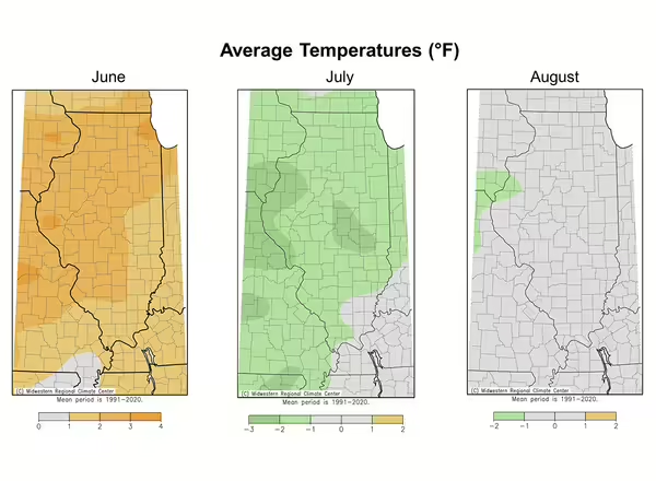
Climatological summer encompasses June, July, and August, and the season often brings more than its fair share of intense weather. This past season was on the mild side, temperature-wise. June started the season with warmer than normal conditions but was succeeded by a cooler than normal July. August wrapped up the summer with near normal temperatures (Figure 1).
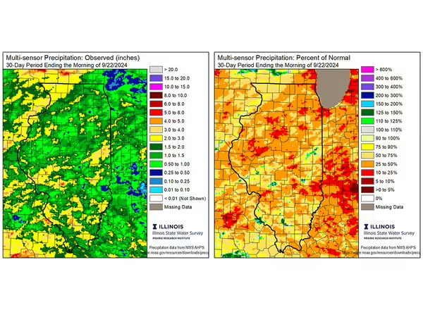
Following a top 5 wettest July in Illinois, the tap shut off in August and the first half of September. Most of the state has seen less than 2 inches of rain since mid-August, less than 50% of normal (Figure 2). At the same time, heat in late August and persistently above normal temperatures in September have worsened dry conditions through more evaporation.


Drought in late September is decidedly different than drought in mid-July, but nonetheless impactful. Agricultural impacts from our current drought situation include deteriorating pasture conditions, moisture stress and potential yield loss in soybeans and late planted corn, and stress from disease and insect pressure that are made worse by dry conditions. The dryness does help progress crop dry-down and timely harvest; however, dry conditions also increase fire risk in fields and adjacent ditches.
This is the time of the year when we typically see the lowest streamflow levels around the state, and the recent dryness has pushed levels and flow well below normal in many streams. The drought affecting Illinois is much worse in Ohio, West Virginia, and eastern Kentucky, and has significantly declined Ohio River flow. Because the lower Mississippi River (south of Cairo) greatly depends on water from the Ohio River, levels along the Mississippi have once again dipped below low stage, threatening barge traffic and other activities along the big river.
Drought impacts and condition reports are critical as drought conditions evolve in coming weeks. Please consider reporting what conditions look like in your area using the Condition Monitoring Observer Reports system: go.illinois.edu/cmor.
The last week or so has been a bit wetter than previous weeks, and moisture from the tropics may continue that wetter trend as we move from September to October. That said, the most recent outlooks from the Climate Prediction Center still lean drier than normal for October and October-December. This suggests we will likely move into a drier pattern yet again as we get into the heart of fall, meaning we’ll need significant winter moisture to help with stream and soil conditions before we get into the next growing season.