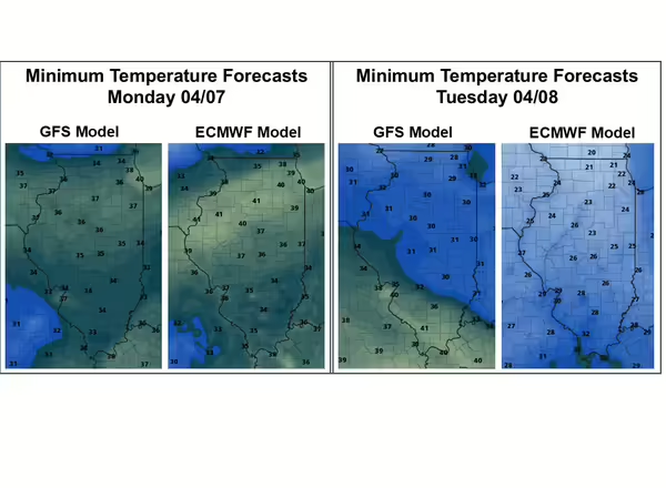
Illinois state climatologist, Trent Ford, shared this updated freeze risk alert for next week. After a warm March and first week of April, unseasonably cold air is going to move into the Midwest and bring a risk of widespread freeze across Illinois. The updated forecasts from the GFS (American) and ECMWF (European) models show minimum temperatures approaching or dipping below freezing overnight between Sunday and Monday and again between Monday and Tuesday (Figure 1). Both models show best chances of below freezing temperatures overnight on Monday into Tuesday morning, but the ECMWF model shows temperatures at or below freezing down to the Ohio River while the GFS model shows the best potential for below freezing temperatures mostly north of Interstate 64.
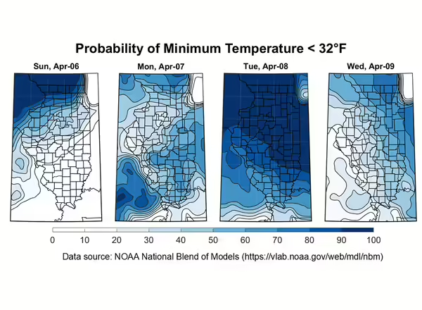
From a different perspective, Figure 2 shows the probability of having overnight minimum temperatures less than 28 degrees and 32 degrees between Sunday, April 6th and Wednesday, April 9th. The best chances of temperatures dipping below 28 or 32 degrees is overnight between Monday and Tuesday. All areas north of Interstate 64 have a 60% or greater chance of seeing temperatures below 28 degrees late Monday night and early Tuesday morning, with areas farther south having a 20 – 40% chance of having sub-28 degree temperatures then.

The entire state has a greater than 50% chance of experiencing sub-freezing (32 degree) temperatures overnight on Monday into Tuesday, with chances exceeding 80% in most places north of Interstate 64. There are smaller, but non-zero chances of temperatures dipping below 32 degrees overnight on Sunday into Monday and again Tuesday into Wednesday this upcoming week as well.
Summary Points:
- There is a significant (>50%) chance of temperatures below 32 degrees across the entire state on Monday (04/07) night into Tuesday (04/08) morning
- There is a significant (>50%) chance of temperatures below 28 degrees mostly north of Interstate 64 on Monday night into Tuesday morning
- It is very likely areas north of Interstate 70 will experience multiple nights of temperatures below 32 degrees and may see temperatures around or below 28 degrees early Tuesday morning.

Spring Freezes
Spring freezes always pose a risk to fruit growers. As plants progress out of dormancy, they become increasingly sensitive to temperatures below freezing. For growers in northern Illinois, apples are currently anywhere from silver tip (15°F/2°F) to tight cluster (27°F/21°F). In this example, the first temperature in parenthesis is the critical temperature where a 10% flower kill would be expected; the second number is the critical temperature where 90% flower kill would be expected. In east central Illinois, early apples like ‘Zestar’ are in first pink (28°F/24°F) and peaches are green calyx (21°F/5°F) to first pink (25°F/15°F). In the southern region, peaches (27°F/24°F) and apples (28°F/25°F) are effectively in full bloom.
According to our Illinois State Climatologist, cloud cover is forecasted to be mostly less than 30% on Sunday night and Monday night, which is helping those temperatures really dip down. And, unfortunately, the wind is expected to die down both of those nights, with sustained winds mostly less than 5 mph. One thing in growers' favor is wet soils do help both retain heat overnight and increase evaporation and humidity. The forecasts are likely not taking the wet soil factor into full account, so that could provide a little boost to overnight temps.
Critical temperatures
Strawberry
Tight Bud: 22°F
Popcorn stage: 26°F
Open Blossom: 30°F
Apple 10% kill / 90% Kill
Silver Tip 15°F / 2°F
Green Tip 18°F / 10°F
½ inch Green 23°F / 15°F
Tight Cluster 27°F / 21°F
First Pink 28°F / 24°F
Full Pink 28°F / 25°F
First Bloom 28°F / 25°F
Full Bloom 28°F/ 25°F
Post Bloom 28°F / 25°F
Peach 10% kill / 90% Kill
Bud Swell 18°F / 1°F
Calyx Green 21°F / 5°F
Calyx Red Tip 23°F / 9°F
First Pink 25°F / 15°F
First Bloom 26°F / 21°F
Full Bloom 27°F / 24°F
Post Bloom 28°F / 25°F