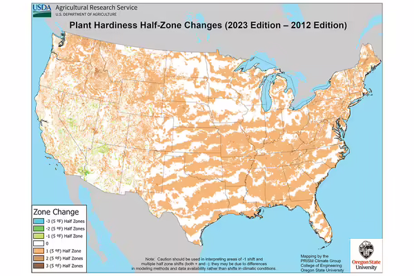
URBANA, Ill. — On a cold, blustery January day, it may be hard to remember that 2023 was the hottest year on record. But the newest update to the plant hardiness map, in which half the country shifted to warmer zones, is a stark reminder that the climate is changing and changing fast.
“The magnitude of change in the new maps really surprised me since it just reflects the last 30 years,” said Illinois State Climatologist Trent Ford. “One of the most consistent changes in Illinois’ climate directly linked to human-caused global warming is warming winters.”
In November, the U.S. Department of Agriculture updated its plant hardiness zone map, giving growers across the nation a better understanding of which perennial plants will survive a region’s winter and thrive long-term. The map, available at planthardiness.ars.usda.gov, was previously updated in 2012, and the new, more detailed version is based on 30-year averages of the lowest annual winter temperatures from almost twice as many weather station sites.
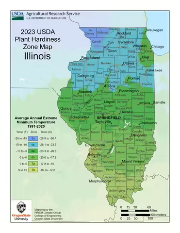
Illinois now has six zones, with 12 sub-zones, ranging from zone 5a in northwestern Illinois to the newly added 7b zone in southern counties.
“In Illinois, the most obvious change between the new hardiness zone map and the 2012 map is a northward progression of zones 6a, 6b, and 7a,” Ford said. “The boundary between zones 5b and 6a migrated 60 miles north, from around Springfield in the 2012 map to around Peoria in the 2023 map.”
On the new map, most of central Illinois now falls into zone 6a, with zone 6b moving north into parts of Coles, Moultrie, and Shelby counties. Zone 7a also migrated 50 miles north from Cairo into the St. Louis Metro East area. This has also pulled a small section of 7b into Illinois, which is the first time this warmer zone has occurred this far north.
Warming winters can reduce stress on plant populations, helping some landscape plants thrive, but also bring negative impacts, such as introducing invasive species from the south, introducing new pest pressure on crops, or ecological competition in natural areas.
“Zones are a shortcut we use when thinking of an area’s general climate and how plants will fare,” said Jamie Viebach, University of Illinois Extension horticulture educator. “The new changes in the map may actually explain trends gardeners have already seen.”
If a gardener’s zone shifted with the new map, Viebach says that’s not a reason to worry or change existing landscaping, but it could be an opportunity to try to overwinter new perennial plants.
Most landscape plants are hardy across a range of zones. A plant known to be hardy from zones 4 to 8 will thrive in zone 6, whereas a plant that is only hardy in zones 6 to 8 may struggle if a winter extreme temperature tips below the expected average as a result of year-to-year variability.
Much of the data that prompted the updated map was collected and submitted by trained members of the public through the Community Collaborative Rain, Hail & Snow Network. Volunteers are needed in Illinois, and more information is available at www.cocorahs.org.
For more information about planting in Illinois, visit extension.illinois.edu/plants or connect with your local county Illinois Extension office at go.illinois.edu/ExtensionOffice.
Sources: Jamie Viebach and Ryan Pankau, horticulture educators. Trent Ford, Illinois State Climatologist.
Images: USDA, planthardiness.ars.usda.gov
Illinois Extension leads public outreach for University of Illinois by translating research into action plans that allow Illinois families, businesses, and community leaders to solve problems, make informed decisions, and adapt to changes and opportunities. Illinois Extension is part of the University of Illinois Urbana-Champaign College of Agricultural, Consumer and Environmental Sciences.