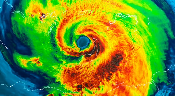
Labor Day weekend is usually considered the last holiday of summer. It’s one last chance to gather with friends and family for a cookout, games, or beach time. On beaches along the Gulf Coast and southern Atlantic Seaboard, this is also a time when people are wary of the weather.
Several major hurricanes have hit the U.S. on Labor Day, and many others have hit within a few days of the holiday weekend. Why does this happen? First, let’s talk about what is needed for a hurricane to form.
What does a hurricane need to develop?
There are several things needed for hurricane development, but I’ll focus on three:
- Warm water, which means at least 80°F or greater
- Weak upper-level winds
- A location away from the equator.
Hurricanes get their energy from warm water. This warm 80-degree water needs to be at least 165 feet deep to continuously supply moisture to feed the storm. If the water that is 80 degrees is too shallow, a hurricane will stir up too much cold water and stop the process. As I’m writing this in mid-July, Gulf of Mexico coast temperatures are in the mid to upper 80s, and many are several degrees above average July temperatures. The National Oceanic Atmospheric Administration has sensors and keeps tabs on Gulf and Atlantic temperatures. According to NOAA, the Gulf of Mexico average water temperature from August through October has risen 1°F to 2°F in the last 40 years. Atlantic temperatures have warmed even more during that three-month period — 2°F to 4°F in the last 30 years.
If winds tens of thousands of feet up are relatively weak or slow that will allow thunderstorm clouds in the hurricane to continue to grow. As hurricanes form, condensation, which occurs when liquid water from water vapor forms clouds, releases more heat into the air. This allows clouds to grow taller and create more condensation, allowing a hurricane to strengthen. Strong upper-level winds cut off the cloud tops, inhibiting hurricane development.
Have you ever heard of a hurricane forming very close to the Equator? You haven’t! Even though the water at the Equator is plenty warm enough, there will be thunderstorms but no hurricanes! This is because of the Coriolis force, which involves the Earth’s rotation and this force. The farther from the Equator, the greater the force or effect is. Hurricanes need some of this Coriolis force to start spinning. Typically, the closest a hurricane will form is at least 350 miles north or south of the Equator.
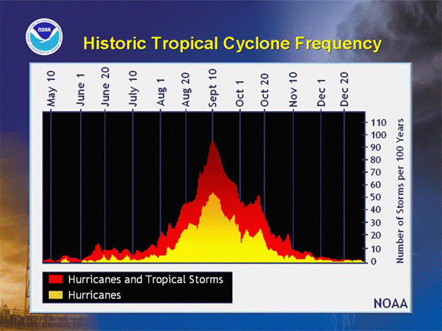
So why do hurricanes occur often on Labor Day?
This goes back to water temperature. The warmest Gulf of Mexico water temperatures occur in early September. Water takes a long time to heat, so even though it’s past when the noon sun is highest, that is when the water is warmest, which in turn helps hurricane development if all conditions are right. September 10 is the peak day. That doesn’t mean that a hurricane will always form or be present on that day, but the potential is highest then.
Here in the Midwest, we may get rain from the leftovers of a hurricane, so just move the Labor Day celebration indoors!
About the Blog
The All About Weather blog by Duane Friend explores the environment, climate, and weather topics for Illinois. Get in-depth information about things your weather app doesn't cover, from summer droughts to shifting weather patterns. Never miss a new post!