Update from Trent Ford, Illinois State Climatologist (217-244-1330; twford@illinois.edu)
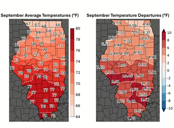
September is the first month of meteorological fall, but I guess no one told the weather. Last month was extremely warm across the state, with average temperatures that were 4 to 10 degrees above average (Figure 1). It’s very likely last month will be one of if not the warmest September on record in Illinois. Across the state, 350 daily temperature records were broken last month, 19 locations set their all-time September high minimum temperature including a low of 78 degrees in Chicago on September 2nd, and 10 locations set their all-time September high maximum temperature including 101 degrees in Salem on September 2nd.
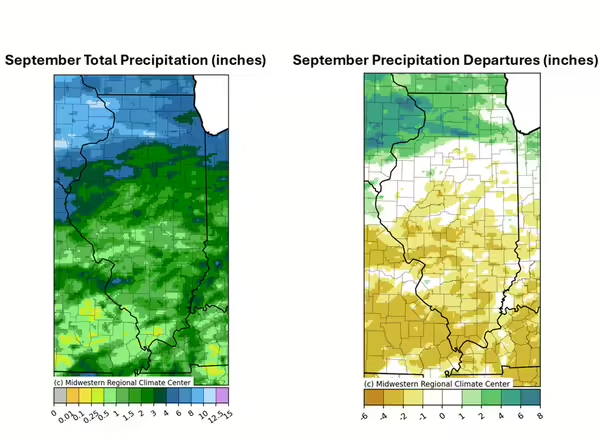
Most of the state south of Interstate 80 was under a strong high pressure system for much of September, keeping central and southern Illinois warm and dry for the first two-thirds of the month. Meanwhile, ridge-riding thunderstorms inundated northern Illinois with repeat rounds of heavy rainfall. The result was a mixed bag of September precipitation ranging from less than half an inch in southwest Illinois to nearly 15 inches in north-central Illinois (Figure 2). The hot, dry weather accelerated crop drying and harvest progress in southern Illinois, while wetter conditions kept a lot of folks out of fields in northern Illinois.
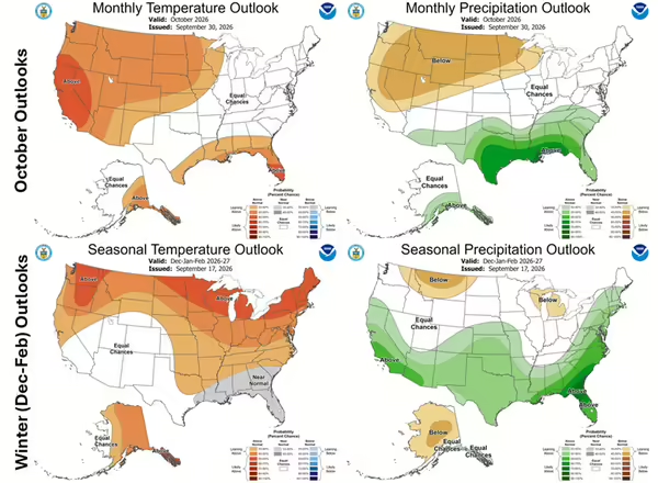
Looking ahead, temperature and precipitation outlooks from the Climate Prediction Center show interesting patterns for both October and meteorological winter (December – February). For October, Illinois is squeezed in between an area of drier conditions in the northern Plains and wetter conditions in the southeast. The first two weeks of October are likely going to be mild and drier, making for some nice fieldwork and tourism days.
Meanwhile, winter outlooks are decidedly El Niño, with milder temperatures across the whole state (Figure 3). Given the very strong El Niño currently and long-term winter warming trends, it is very likely the 2026-27 winter will be warmer than average. El Niño typically has less influence on winter precipitation in Illinois, and snow and ice are always possibilities even in warmer winters.